Chapels · 20th Century
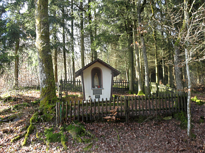
Wallfahrtskapelle im Mühlbachtal
Sogenannte Prozessionskapelle


Description
This description is only available in German.
Translate with Google opens this page in Google Translate (external service)
Der Bau geht zurück auf ein Gelübde aus dem Zweiten Weltkrieg. 1964 wurde die Votivkapelle, eigentlich ein großer, überdachter Bildstock, errichtet.
Inschrift obere Tafel:
Errichtet aus Dankbarkeit
von den Bewohnern der
Pfarr-Gemeinde Preischeid
für Hilfe in der Kriegsnot
am 11.September 1944
Inschrift untere Tafel:
1964 [1]
Classification
- Subject area
- Architectural and Art Monuments
- Category
- Religious Buildings
- Object type
- Chapels
- Date
- 1964
- Period
- 20th Century
Location
- District
- Eifelkreis Bitburg-Prüm
- Collective municipality
- Arzfeld
- Municipality
- Preischeid
- Field name
- Unterste Mühle
- Coordinates
- WGS 84: 50.036379, 6.165625 (Position: exact) WGS 84: 50° 02′ 11.0″ N, 6° 09′ 56.3″ E UTM 32 (ETRS89): E 297036 · N 5546525
Sources
Data sources
- [1] Rund um die Kirche im Dorf - Kirchen und Kapellen der Westeifel. Hrsg. Geschichtsverein Prümer Land, Prüm, 2004. ISBN: 3-931478-14-9 http://www.gvpl.de/
On the internet
Picture credits
Last edited: 22 Feb 2015 Object ID: 11023
https://kulturdb.de/en/objekt/11023-preischeid-wallfahrtskapelle-im-muehlbachtal
Nearby
The nearest objects
Field Names
Lanzenborn
Field Names
Grubenborn
Field Names
Rennersdell
Field Names
Diebendell
Field Names
Unterm Mayersborn
Fortresses and Bunkers
Westwall - Sanitätsstand
Fortresses and Bunkers
Westwall - Bunker ohne Kampfraum
Fortresses and Bunkers