Wayside Shrines and Stations of the Cross · Renaissance
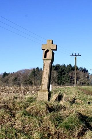
Nischenkreuz
An der Straße nach Seinsfeld
- Listed monument


© GeoBasis-DE / LVermGeoRP, dl-de/by-2-0
There is no picture of this object yet. Do you have a photo that you would like to make available to the Kulturdatenbank? Submit a picture
Description
This description is only available in German.
Translate with Google opens this page in Google Translate (external service)
[...] ca. 150 m südlich der Kreuzung mit der Straße Kyllburg-Oberkail: Unverziertes Nischenkreuz mit schmal abgefastem Schaft. Das Abschlußkreuz sitzt ohne Stamm direkt auf dem Nischendach. Wohl 16. oder frühes 17. Jahrhundert. [1]
Classification
- Subject area
- Architectural and Art Monuments
- Category
- Religious Buildings
- Object type
- Wayside Shrines and Stations of the Cross
- Date
- 16. Jahrhundert
- Period
- Renaissance
Location
- District
- Eifelkreis Bitburg-Prüm
- Collective municipality
- Bitburger Land
- Municipality
- Orsfeld
- Field name
- Beim Achtlicherkreuz
- Coordinates
- WGS 84: 50.039350, 6.631420 (Position: exact) WGS 84: 50° 02′ 21.7″ N, 6° 37′ 53.1″ E UTM 32 (ETRS89): E 330398 · N 5545694
Sources
Data sources
- [1] Denkmaltopographie Bundesrepublik Deutschland, Kulturdenkmäler in Rheinland-Pfalz, Kreis Bitburg-Prüm, 9.1 Wernersche Verlagsgesellschaft 1994. ISBN 3-88462-081-9
On the internet
Last edited: 30 Apr 2009 Object ID: 13623
https://kulturdb.de/en/objekt/13623-orsfeld-nischenkreuz
Nearby
The nearest objects
 320 m
Wayside Shrines and Stations of the Cross
Erneuertes Nischenkreuz
Field Names
Auf Pütz
Extraction and Processing of Raw Materials
Ehemalige Ziegelei am Rosenberg
Field Names
Kirchbüsch
Field Names
Pütz
Field Names
Im Kirchbüsch
Field Names
Im Kirchbüsch
Surveying