Wayside Shrines and Stations of the Cross · Historicism / Art Nouveau
Wegekreuz östlich der Ortslage
- Listed monument


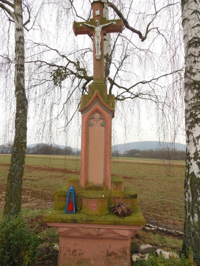


Description
This description is only available in German.
Translate with Google opens this page in Google Translate (external service)
Classification
- Subject area
- Architectural and Art Monuments
- Category
- Religious Buildings
- Object type
- Wayside Shrines and Stations of the Cross
- Date
- Ende des 19. Jahrhunderts
Location
- District
- Bernkastel-Wittlich
- Collective municipality
- Wittlich-Land
- Municipality
- Altrich
- Field name
- Auf der Großen Geige
- Coordinates
- WGS 84: 49.955886, 6.925427 (Position: exact) WGS 84: 49° 57′ 21.2″ N, 6° 55′ 31.5″ E UTM 32 (ETRS89): E 351191 · N 5535789
Sources
Data sources
- [1] Denkmalliste des Landkreises Bernkastel-Wittlich, Juni 2008. Kreisverwaltung Bernkastel-Wittlich, Fachbereich Beraten, Planen, Fördern. Postfach 1420, 54504 Wittlich.
- [2] Helmut Bauer, Trier, 2023.
On the internet
Picture credits
Last edited: 1 Jun 2023 Object ID: 14867
https://kulturdb.de/en/objekt/14867-altrich-wegekreuz-oestlich-der-ortslage
Nearby
The nearest objects
No picture
270 m
Field Names
Unterm Brühlborn
No picture
280 m
Field Names
Im Rothfeld
No picture
310 m
Field Names
Auf Pfefferrech
 400 m
Road Transport
Reste einer alten Brücke
No picture
490 m
Field Names
Unterm Brühlborn
No picture
530 m
Field Names
Auf dem obersten Pfeffersrech
No picture
600 m
Aviation
Ehemaliger Feldflugplatz Wengerohr
No picture
650 m
Field Names