Wayside Shrines and Stations of the Cross · Baroque / Rococo
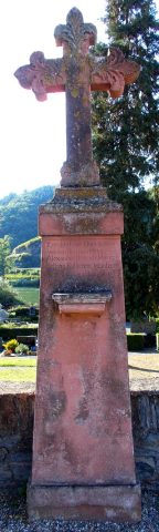
Kreuzigungsbildstock auf dem Friedhof
- Listed monument


© GeoBasis-DE / LVermGeoRP, dl-de/by-2-0
There is no picture of this object yet. Do you have a photo that you would like to make available to the Kulturdatenbank? Submit a picture
Description
This description is only available in German.
Translate with Google opens this page in Google Translate (external service)
Römerstraße, an der neuen Leichenhalle auf dem Friedhof. Barocker Kreuzigungsbildstock. [1]
Classification
- Subject area
- Architectural and Art Monuments
- Category
- Religious Buildings
- Object type
- Wayside Shrines and Stations of the Cross
- Date
- Circa 1700 bis circa 1780
- Period
- Baroque / Rococo
Location
- District
- Bernkastel-Wittlich
- Collective municipality
- Bernkastel-Kues
- Municipality
- Neumagen-Dhron
- Locality / location
- Neumagen
- Street
- Römerstraße
- Field name
- Ortslage
- Coordinates
- WGS 84: 49.858528, 6.896404 (Position: exact) WGS 84: 49° 51′ 30.7″ N, 6° 53′ 47.1″ E UTM 32 (ETRS89): E 348805 · N 5525024
Sources
Data sources
- [1] Denkmalliste des Landkreises Bernkastel-Wittlich, Juni 2008. Kreisverwaltung Bernkastel-Wittlich, Fachbereich Beraten, Planen, Fördern. Postfach 1420, 54504 Wittlich.
On the internet
Last edited: 15 Feb 2026 Object ID: 15846
https://kulturdb.de/en/objekt/15846-neumagen-dhron-kreuzigungsbildstock-auf-dem-friedhof
Nearby
The nearest objects
Lime Kilns
Ehemaliger Kalkofen
 90 m
War Memorials
Friedhofskreuz
Ferries
Ehemalige Fähre Neumagen-Zweibacher Hof
Vineyard Sites
Engelgrube
Town Houses and Commercial Buildings
Wohnhaus
Railways
Moseltalbahn - Ehemaliger Bahnhof
Town Houses and Commercial Buildings
Winzervilla
Vineyard Sites