Deserted Settlements · Baroque / Rococo
Gipperather Mühle (2)


Description
This description is only available in German.
Translate with Google opens this page in Google Translate (external service)
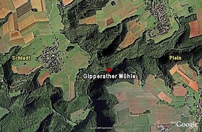
Mahl- und Ölmühle im Mündungsbereich Finsterbach / Lambach. Entstehungszeit nach 1700, im Jahre 1888 abgerissen.
Classification
- Subject area
- Archaeological Monuments
- Category
- Settlements
- Object type
- Deserted Settlements
- Date
- Nach 1700
- Period
- Baroque / Rococo
Location
- District
- Bernkastel-Wittlich
- Collective municipality
- Wittlich-Land
- Municipality
- Gipperath
- Field name
- Mühlenberg
- Coordinates
- WGS 84: 50.031586, 6.852734 (Position: presumed) WGS 84: 50° 01′ 53.7″ N, 6° 51′ 09.8″ E UTM 32 (ETRS89): E 346219 · N 5544352
Sources
Data sources
- Günter Hesse und Wolfgang Schmitt-Kölzer: Manderscheid. Hrsg.: Verbandsgemeinde Manderscheid 1986.
On the internet
de.wikipedia.org/wiki/Gipperath
Picture credits
Last edited: 1 Nov 2008 Object ID: 16632
https://kulturdb.de/en/objekt/16632-gipperath-gipperather-muehle-2
Nearby
The nearest objects
 20 m
Deserted Settlements
Gipperather Mühle (1)
No picture
60 m
Field Names
Metzenwiese
No picture
170 m
Field Names
Kirchberg
No picture
260 m
Field Names
Spann
No picture
340 m
Field Names
In der Hinteren Kopswies
No picture
390 m
Field Names
Kirchenwiese
No picture
400 m
Field Names
Kopwieser Hist
No picture
420 m
Field Names