Wayside Shrines and Stations of the Cross · Undated
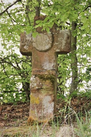
Wegekreuz westlich Hengscheid


Description
This description is only available in German.
Translate with Google opens this page in Google Translate (external service)
130 m südwestlich vom Höhenpunkt 549 m über Normal-Null..
Classification
- Subject area
- Architectural and Art Monuments
- Category
- Religious Buildings
- Object type
- Wayside Shrines and Stations of the Cross
- Date
- Undatiert
- Period
- Undated
Location
- District
- Eifelkreis Bitburg-Prüm
- Collective municipality
- Prüm
- Municipality
- Büdesheim
- Field name
- Hengscheid
- Coordinates
- WGS 84: 50.212252, 6.563372 (Position: exact) WGS 84: 50° 12′ 44.1″ N, 6° 33′ 48.1″ E UTM 32 (ETRS89): E 326153 · N 5565072
Sources
Data sources
- Dagmar Moss, Bitburg, 2009.
On the internet
eifeldorf-buedesheim.de/index.html
Picture credits
Last edited: 6 Oct 2010 Object ID: 17323
https://kulturdb.de/en/objekt/17323-buedesheim-wegekreuz-westlich-hengscheid
Nearby
The nearest objects
No picture
210 m
Field Names
Hinter Hostert
 290 m
Settlements
Römische Siedlungsstelle
No picture
320 m
Caves
Manöverhöhle
No picture
390 m
Field Names
Auf Zangenheld
No picture
400 m
Lime Kilns
Ehemaliger Kalkofen
 400 m
Wayside Shrines and Stations of the Cross
Schaftkreuz
No picture
420 m
Field Names
Hinter Hostert
No picture
430 m
Burial Mounds