Settlements · Celtic / Roman Period
Siedlungsreste Weidenborn

Classification
- Subject area
- Archaeological Monuments
- Category
- Settlements
- Object type
- Settlements
- Date
- Circa 500 vor Chr. bis circa 500 nach Chr.
- Period
- Celtic / Roman Period
Location
- District
- Trier-Saarburg
- Collective municipality
- Trier-Land
- Municipality
- Ralingen
- Locality / location
- Olk
- Field name
- Hinter Weidenborn
- Coordinates
- WGS 84: 49.806400, 6.561420 (Position: exact) WGS 84: 49° 48′ 23.0″ N, 6° 33′ 41.1″ E UTM 32 (ETRS89): E 324542 · N 5519959
Sources
Data sources
- [1] Fundkarte des südlichen Langmauerbezirks. Auszug aus den Mtbl. Welschbillig 6105 und Trier 6205. In: Trierer Zeitschrift für Geschichte und Kunst des Trierer Landes und seiner Nachbargebiete. Hrsg. Rheinisches Landesmuseum Trier; 34. Jahrgang, 1971. Paulinus Verlag. www.landesmuseum-trier-shop.de
On the internet
dainst.org/medien/de/krausse.pdf
Picture credits
- Picture 1: © Lothar Monshausen, Fotostream http://www.flickr.com/photos/lomo56/tags/meteorite/
Last edited: 12 Nov 2017 Object ID: 17814
https://kulturdb.de/en/objekt/17814-ralingen-siedlungsreste-weidenborn
Nearby
The nearest objects
No picture
120 m
Field Names
Hinter Weidenborn
No picture
230 m
Field Names
Weidenborn
No picture
310 m
Field Names
Oberst Weidenborn
No picture
370 m
Field Names
In Weidenborn
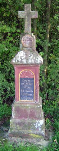 370 m
Wayside Shrines and Stations of the Cross
Wegekreuz am Weidenborn
 380 m
Settlements
Römische Siedlungsstelle
 400 m
Field Names
Zu Haargarten hinter der Höhe
No picture
420 m
Field Names