Rocks · Undated
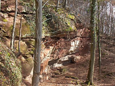
Eremitenfels


Description
This description is only available in German.
Translate with Google opens this page in Google Translate (external service)
Unmittelbar unter dem [Eremitenfels] befindet sich linker Hand eine alte Eremitage. Dort soll bis Juli 1895 ein 82 jähriger Einsiedler gelebt haben, der dann auf mysteriöse Weise verschwand. (Quelle: Paulinusblatt vom 21. Juli 1895) Die rechteckigen Grundmauern und der halb verschütte Eingang der Eremitage, sowie weitere Treppen und Mauern aus Stein sind noch gut zu erkennen. [1]
Classification
- Subject area
- Natural Features
- Category
- Rocks
- Date
- Undatiert
- Period
- Undated
Location
- District
- Trier-Saarburg
- Collective municipality
- Trier-Land
- Municipality
- Aach
- Field name
- Emetage
- Coordinates
- WGS 84: 49.783200, 6.619780 (Position: exact) WGS 84: 49° 46′ 59.5″ N, 6° 37′ 11.2″ E UTM 32 (ETRS89): E 328659 · N 5517245
Sources
Data sources
- [1] A cache by RoundBox1&nain zusammen mit den Lohne´s Versteckt : 12/27/2009 http://www.geocaching.com/seek/cache_details.aspx?guid=a21324a9-550…
On the internet
Picture credits
Last edited: 6 Mar 2015 Object ID: 23157
https://kulturdb.de/en/objekt/23157-aach-eremitenfels
Nearby
The nearest objects
 less than 10 m
Hermitages
Ehemalige Eremitage
Extraction and Processing of Raw Materials
Römischer Sandsteinbruch
Extraction and Processing of Raw Materials
Ehemaliger Steinbruch
Field Names
Auf dem Flachskopf
Field Names
Im Grund
Field Names
Auf dem Flachskopf
 420 m
Thujas
Lebensbaum am Forsthaus Altenhof
440 m
Thujas