Execution Sites · Baroque / Rococo
Galgen
Description
This description is only available in German.
Translate with Google opens this page in Google Translate (external service)
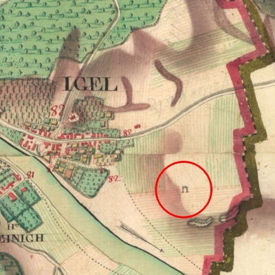
Die Ferraris-Karte der Österreichischen Niederlande von 1777 zeigt einen Galgen bei Igel. [1]
Classification
- Subject area
- History
- Category
- Legal Monuments
- Object type
- Execution Sites
- Date
- 1777
- Period
- Baroque / Rococo
Location
- District
- Trier-Saarburg
- Collective municipality
- Trier-Land
- Municipality
- Igel
- Field name
- Langfuhr
- Coordinates
- WGS 84: 49.707200, 6.558100 (Position: exact) WGS 84: 49° 42′ 25.9″ N, 6° 33′ 29.2″ E UTM 32 (ETRS89): E 323944 · N 5508939
Sources
Data sources
- [1] Werner Weber (Eisenach): Galgen im ehemaligen Luxemburger Grenzland und im Bitburger Land von https://www.weber-eisenach.de/assets/images/web/pdf/Galgen_im_ehema…
- und Ferraris Karte von: Bibliothèque royale de Belgique: La carte de Ferraris
On the internet
Picture credits
Last edited: 7 Aug 2025 Object ID: 24658
https://kulturdb.de/en/objekt/24658-igel-galgen
Nearby
The nearest objects
No picture
80 m
Fortresses and Bunkers
Westwall - Maschinengewehr-Schartenstand
No picture
90 m
Fortresses and Bunkers
Westwall - Maschinengewehr-Schartenstand
No picture
100 m
Settlements
Fundamente römischer Gebäude
No picture
130 m
Field Names
Langfuhr
No picture
130 m
Fortresses and Bunkers
Westwall - Maschinengewehr-Schartenstand
No picture
130 m
Fortresses and Bunkers
Westwall - Maschinengewehr-Schartenstand
No picture
190 m
Fortresses and Bunkers
Westwall - Panzerabwehrkanonen-Stand
No picture
190 m
Fortresses and Bunkers