Wayside Shrines and Stations of the Cross · 20th Century
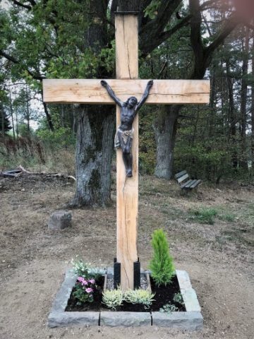
Ölmühlenkreuz

Description
This description is only available in German.
Translate with Google opens this page in Google Translate (external service)
Ursprünglich trug es die Inschrift I K I H - Im Kreuz ist Heil. Errichtet wurde es von den Eltern eines Soldaten, der im 2. Weltkrieg vermist wurde. [...] Nachdem das Kreuz einige Zeit verfallen war, wurde im Jahre 1991 durch die Gemeinde ein neues Kreuz aufgestellt. [1]
Classification
- Subject area
- Architectural and Art Monuments
- Category
- Religious Buildings
- Object type
- Wayside Shrines and Stations of the Cross
- Date
- 1925
- Period
- 20th Century
Location
- District
- Trier-Saarburg
- Collective municipality
- Hermeskeil
- Municipality
- Rascheid
- Street
- Bahnhofstraße
- Field name
- Auf dem Dickersflur
- Coordinates
- WGS 84: 49.715181, 6.929586 (Position: exact) WGS 84: 49° 42′ 54.7″ N, 6° 55′ 46.5″ E UTM 32 (ETRS89): E 350750 · N 5509022
Sources
Data sources
- [1] Aus dem Hochwald. Wegekreuze und Gedenksteine. Hrsg. Arbeitskreis Heimatkunde Bildungswerk Johanneshaus Hermeskeil. Hermeskeil 1991.
On the internet
Picture credits
- Picture 1: © Norbert Kutscher, Waldweiler, 2015.
Last edited: 7 Apr 2015 Object ID: 24892
https://kulturdb.de/en/objekt/24892-rascheid-oelmuehlenkreuz
Nearby
The nearest objects
Field Names
In der Wolfskaul
Field Names
In der Bornacht
Wayside Shrines and Stations of the Cross
Dankeskreuz
Mills
Ehemalige Sägemühle
Field Names
Beckerstriesch
Field Names
Vor dem Wittum
Field Names
In den Murtengärten
 550 m
Wayside Shrines and Stations of the Cross