Wayside Shrines and Stations of the Cross · 20th Century
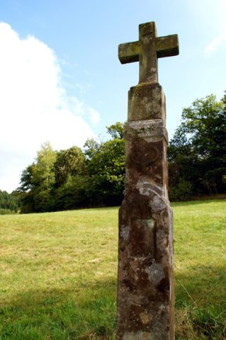
Ämeskreuz


Description
This description is only available in German.
Translate with Google opens this page in Google Translate (external service)
Eichenkreuz. [...] An dieser Stelle stand bereits seit 1871 ein Kreuz, das mehrmals erneuert wurde, aber seit Jahren verfallen und verschwunden war. Es trug die Inschrifttafel:"Errichtet von Matthias Breidt aus Geisfeld zum Dank gegen Gott für den Schutz im Feldzug 1870/71." Mathias Breidt nahm damals an dem Feldzug gegen Frankreich teil. Als er gesund zurückkehrte, ließ er dieses Kreuz errichten, das nach seinem Hausnamen Ämeskreuz genannt wurde. [1]
Classification
- Subject area
- Architectural and Art Monuments
- Category
- Religious Buildings
- Object type
- Wayside Shrines and Stations of the Cross
- Date
- Nach 1918
- Period
- 20th Century
Location
- District
- Trier-Saarburg
- Collective municipality
- Hermeskeil
- Municipality
- Geisfeld
- Field name
- Auf dem Habeltberg
- Coordinates
- WGS 84: 49.716107, 6.968995 (Position: exact) WGS 84: 49° 42′ 58.0″ N, 6° 58′ 08.4″ E UTM 32 (ETRS89): E 353593 · N 5509047
Sources
Data sources
- [1] Aus dem Hochwald. Wegekreuze und Gedenksteine. Hrsg. Arbeitskreis Heimatkunde Bildungswerk Johanneshaus Hermeskeil. Hermeskeil 1991.
On the internet
Picture credits
Last edited: 14 Sep 2013 Object ID: 25327
https://kulturdb.de/en/objekt/25327-geisfeld-aemeskreuz
Nearby
The nearest objects
Field Names
Auf dem Malborner Weg
Field Names
Hohrech
Field Names
Im Höllenloch
Field Names
Fuchsborn
Field Names
Im Krummen Acker
Field Names
In der Faulen Anwand
Field Names
Im Regenbogen
 730 m
Wayside Shrines and Stations of the Cross