Wayside Shrines and Stations of the Cross · Historicism / Art Nouveau
Wegekreuz bei der Kapelle


Description
This description is only available in German.
Translate with Google opens this page in Google Translate (external service)
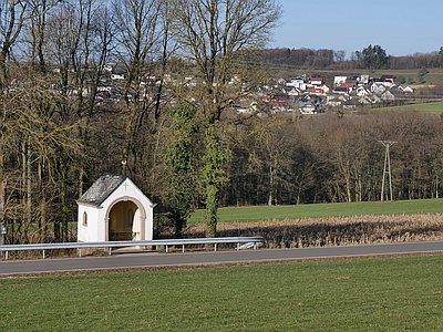
Das Kreuz stand vormals im Gewann 'Auf dem vordersten Bälk' (lon: 6.620347 lat: 49.79833), es wurde im Zuge des Neubaus der Kreisstraße 26 um ein paar Meter nach Norden versetzt. Es steht nun gleich neben der kleinen Kapelle.
Inschrift:
Markus Enders
und d. Ehegattin
Eva Fisch
aus Lorig.
Errichtet
zur ehre Gottes
1860. [1]
Classification
- Subject area
- Architectural and Art Monuments
- Category
- Religious Buildings
- Object type
- Wayside Shrines and Stations of the Cross
- Date
- 1860
Location
- District
- Trier-Saarburg
- Collective municipality
- Trier-Land
- Municipality
- Newel
- Locality / location
- Lorich
- Field name
- Beim Messenweg
- Coordinates
- WGS 84: 49.799670, 6.619450 (Position: exact) WGS 84: 49° 47′ 58.8″ N, 6° 37′ 10.0″ E UTM 32 (ETRS89): E 328693 · N 5519076
Sources
Data sources
- [1] Hermann Ameling, Newel, 2017.
On the internet
Picture credits
Last edited: 25 Jan 2017 Object ID: 25340
https://kulturdb.de/en/objekt/25340-newel-wegekreuz-bei-der-kapelle
Nearby
The nearest objects
 less than 10 m
Chapels
Kapelle
Field Names
Beim Messenweg
Cremation Graves
Brandgräber
Field Names
Rodung
Forest Names
Beßlicher Wald
 270 m
Settlements
Römische Siedlungsstelle
Cremation Graves
Römische Brandgräber
Extraction and Processing of Raw Materials