Wayside Shrines and Stations of the Cross · Undated
Wegekreuz


Description
This description is only available in German.
Translate with Google opens this page in Google Translate (external service)
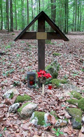
Gusseisernes Wegekreuz mit Schrifttafel am Waldrand, zur Erinnerung an ein Unglück.
Inschrift:
Hier
wurde vom
Blitz
tot getroffen
Ww. Kath.
Thömmes
am
29. Mai 1929 [1]
Classification
- Subject area
- Architectural and Art Monuments
- Category
- Religious Buildings
- Object type
- Wayside Shrines and Stations of the Cross
- Date
- Undatiert
- Period
- Undated
Location
- District
- Trier-Saarburg
- Collective municipality
- Ruwer
- Municipality
- Morscheid
- Field name
- Oberster Wald
- Coordinates
- WGS 84: 49.710498, 6.752046 (Position: exact) WGS 84: 49° 42′ 37.8″ N, 6° 45′ 07.4″ E UTM 32 (ETRS89): E 337937 · N 5508869
Sources
Data sources
- [1] Michael Grün, Trier, 2021.
On the internet
Picture credits
Last edited: 21 Jun 2021 Object ID: 26094
https://kulturdb.de/en/objekt/26094-morscheid-wegekreuz
Nearby
The nearest objects
Field Names
Hinter dem Hundsborn
Field Names
Bei Hundsborn
Field Names
Die Hundsbornwiese
Field Names
Hinter dem Hundsbornwald
Field Names
Scharz bei Hundsborn
 400 m
Wayside Shrines and Stations of the Cross
Gedenkkreuz T.Sgt. David L. Blue
Field Names
4. Gewann hinter dem Hundsborn
Field Names