Wayside Shrines and Stations of the Cross · Undated
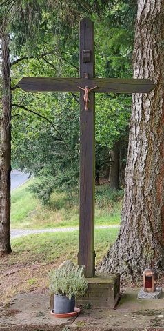
Wegekreuz


Description
This description is only available in German.
Translate with Google opens this page in Google Translate (external service)
Säulenschaftkreuz, zum Sockel hin bauchige Erweiterung. Am Sockel Zahleninschrift, die untere mit 9.4. noch zu entziffern. Position im Waldhang, ca. 50m vom Weg versetzt. [1]
Classification
- Subject area
- Architectural and Art Monuments
- Category
- Religious Buildings
- Object type
- Wayside Shrines and Stations of the Cross
- Date
- Undatiert
- Period
- Undated
Location
- District
- Trier-Saarburg
- Collective municipality
- Schweich an der römischen Weinstraße
- Municipality
- Mehring
- Field name
- Reichenkauf
- Coordinates
- WGS 84: 49.783321, 6.834732 (Position: exact) WGS 84: 49° 47′ 00.0″ N, 6° 50′ 05.0″ E UTM 32 (ETRS89): E 344131 · N 5516789
Sources
Data sources
- [1] Michael Grün, Trier, 2021.
On the internet
Picture credits
Last edited: 13 Sep 2021 Object ID: 32391
https://kulturdb.de/en/objekt/32391-mehring-wegekreuz
Nearby
The nearest objects
Field Names
In der Buchholzwies
 500 m
Wayside Shrines and Stations of the Cross
Hasenkreuz
Viewpoints
Aussichtspunkt Mehringer Höhe
Wayside Shrines and Stations of the Cross
Wegekreuz
Vineyard Sites
Goldkupp
 840 m
Oaks
Eiche an der Landesstraße 150
 920 m
Place Names / Local History
Wolfsfang
Field Names