Wayside Shrines and Stations of the Cross · Historicism / Art Nouveau
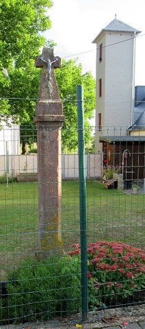
Wegekreuz


Description
This description is only available in German.
Translate with Google opens this page in Google Translate (external service)
An dem ehemals ins südöstlich gelegene Röhl führende Weg steht ein Schaftkreuz. Sein schlanker, gebauchter Schaft ist auf 1857 datiert. Das Aufsatzkreuz ist mit Herzen belegt und trägt einen gußeisernen Korpus. [1]
Schaftkreuz aus Sandstein, reliefierter Korpus [beschädigt] und Ornamente am Kreuz, verwittert. [2]
Classification
- Subject area
- Architectural and Art Monuments
- Category
- Religious Buildings
- Object type
- Wayside Shrines and Stations of the Cross
- Date
- 1857
Location
- District
- Eifelkreis Bitburg-Prüm
- Collective municipality
- Verbandsfreie Gemeinde Bitburg
- Town
- Bitburg
- Locality / location
- Mötsch
- Field name
- Auf Rotherhöh
- Coordinates
- WGS 84: 49.958243, 6.557351 (Position: exact) WGS 84: 49° 57′ 29.7″ N, 6° 33′ 26.5″ E UTM 32 (ETRS89): E 324800 · N 5536848
Sources
Data sources
- [1] Denkmaltopographie Bundesrepublik Deutschland, Kulturdenkmäler in Rheinland-Pfalz, Kreis Bitburg-Prüm, 9.2 Wernersche Verlagsgesellschaft 1994. ISBN 3-88462-132-7
- [2] Michael Grün, Trier, 2022.
On the internet
Picture credits
Last edited: 14 Sep 2022 Object ID: 32660
https://kulturdb.de/en/objekt/32660-bitburg-wegekreuz
Nearby
The nearest objects
Field Names
Auf Rotherhöh
Field Names
In der Ritt hinter der Rotherhö
Field Names
Auf der obersten Rotherhöh
Field Names
Auf der untersten Rotherhöh
Field Names
Hinter der Rotherhöh
Field Names
Aufm Mäusrech
Schools
Ehemalige Schule und Lehrerwohnung
 510 m
Wayside Shrines and Stations of the Cross