Wayside Shrines and Stations of the Cross · Renaissance
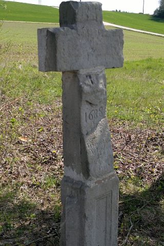
Wegekreuz


Description
This description is only available in German.
Translate with Google opens this page in Google Translate (external service)
Inschrift:
JHS
1615
K L R
Classification
- Subject area
- Architectural and Art Monuments
- Category
- Religious Buildings
- Object type
- Wayside Shrines and Stations of the Cross
- Date
- 1615
- Period
- Renaissance
Location
- District
- Trier-Saarburg
- Collective municipality
- Trier-Land
- Municipality
- Newel
- Locality / location
- Beßlich
- Field name
- Landsbach
- Coordinates
- WGS 84: 49.801730, 6.613231 (Position: exact) WGS 84: 49° 48′ 06.2″ N, 6° 36′ 47.6″ E UTM 32 (ETRS89): E 328253 · N 5519320
Sources
Data sources
- [1] Jörg Busch, Trier-Biewer, 2017.
On the internet
Picture credits
Last edited: 3 Jul 2017 Object ID: 33392
https://kulturdb.de/en/objekt/33392-newel-wegekreuz
Nearby
The nearest objects
No picture
180 m
Field Names
Im Landsberg ober dem Landsborn
 250 m
Settlements
Römische Siedlungsstelle
No picture
280 m
Settlements
Villenanlage
No picture
300 m
Forest Names
Beßlicher Wald
No picture
410 m
Field Names
Auf dem Onner
No picture
420 m
Field Names
Hinter der Kalkesheck
 530 m
Wayside Shrines and Stations of the Cross
Wegekreuz
550 m
Settlements