Wayside Shrines and Stations of the Cross · Renaissance
Wegekreuz
- Listed monument


Description
This description is only available in German.
Translate with Google opens this page in Google Translate (external service)
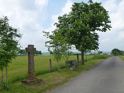
Hohes Balkenkreuz aus Rotsandstein auf quadratischem Setzstein. Das Kreuz mit kurzen Kreuzbalken trägt als Relief eingemeißelt ein Kreuz mit lilienförmigen Abschlüssen. Am Kreuzfuß die Inschrift 1682 THELEN MEST. M ZV WEIL (Thelken Matth. Meier zu Hofweiler). Das am Schaft durch frühere Beschädigung verkürzte Flurkreuz ist Beispiel für eine auch in Butzweiler erhaltene Kreuzform des 17. Jahrhunderts. [1]
Classification
- Subject area
- Architectural and Art Monuments
- Category
- Religious Buildings
- Object type
- Wayside Shrines and Stations of the Cross
- Date
- 1682
- Period
- Renaissance
Location
- District
- Trier-Saarburg
- Collective municipality
- Trier-Land
- Municipality
- Welschbillig
- Locality / location
- Hofweiler
- Street
- Waldstraße
- Field name
- Auf der Altgaß
- Coordinates
- WGS 84: 49.865040, 6.629800 (Position: exact) WGS 84: 49° 51′ 54.1″ N, 6° 37′ 47.3″ E UTM 32 (ETRS89): E 329668 · N 5526320
Sources
Data sources
- [1] Denkmaltopographie Bundesrepublik Deutschland. Kulturdenkmäler in Rheinland-Pfalz. Band 12.2 Kreis Trier-Saarburg. Wernersche Verlagsgesellschaft mbH, Worms. ISBN 3-88462-110-6 (1. Auflage 1994)
On the internet
Picture credits
Last edited: 11 Jun 2015 Object ID: 39078
https://kulturdb.de/en/objekt/39078-welschbillig-wegekreuz
Nearby
The nearest objects
 less than 10 m
Viewpoints
Aussichtspunkt
 190 m
Wayside Shrines and Stations of the Cross
Sogenanntes Brotkreuz
Field Names
Neupesch
Charcoal Kilns
Ehemaliger Meilerplatz
Charcoal Kilns
Ehemaliger Meilerplatz
 390 m
Farmhouses and Farm Buildings
Winkelhof
 400 m
Fountains and Wells
Laufbrunnen
Field Names