Field Names · Undated
Hinter Kappestrüsch


© GeoBasis-DE / LVermGeoRP, dl-de/by-2-0
There is no picture of this object yet. Do you have a photo that you would like to make available to the Kulturdatenbank? Submit a picture
Description
This description is only available in German.
Translate with Google opens this page in Google Translate (external service)
Kappes - Bedeutung: Kohl, Brascia capitata; bezeichnet die Nutzungsart des betreffenden Grundstücks.[1]
Classification
- Subject area
- History
- Category
- Field Names
- Date
- Undatiert
- Period
- Undated
Location
- District
- Bernkastel-Wittlich
- Collective municipality
- Wittlich-Land
- Municipality
- Bergweiler
- Field name
- Hinter Kappestrüsch
- Coordinates
- WGS 84: 49.961247, 6.830344 (Position: exact) WGS 84: 49° 57′ 40.5″ N, 6° 49′ 49.2″ E UTM 32 (ETRS89): E 344389 · N 5536578
Sources
Data sources
- [1] Heinrich Dittmaier: Rheinische Flurnamen. Ludwig Röhrscheid Verlag, Bonn, 1963.
On the internet
Last edited: 17 Nov 2016 Object ID: 41672
https://kulturdb.de/en/objekt/41672-bergweiler-hinter-kappestruesch
Nearby
The nearest objects
 350 m
Settlements
Römische Siedlungsreste
 570 m
Roman Tombs
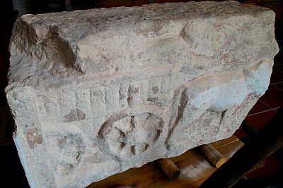
Römischer Grabstein im Eifel-Heimatmuseum
Catholic Churches
Sankt Johannes (Evangelist)
War Memorials
Friedhofskreuz
Field Names
Am Kirchenfeld
Farmhouses and Farm Buildings
Streckhof
Wayside Shrines and Stations of the Cross
Wegekreuz
Wayside Shrines and Stations of the Cross