Chapels · Neoclassicism
Ehemalige Kapelle


© GeoBasis-DE / LVermGeoRP, dl-de/by-2-0
There is no picture of this object yet. Do you have a photo that you would like to make available to the Kulturdatenbank? Submit a picture
Classification
- Subject area
- Architectural and Art Monuments
- Category
- Religious Buildings
- Object type
- Chapels
- Date
- 1803
- Period
- Neoclassicism
Location
- District
- Bernkastel-Wittlich
- Collective municipality
- Bernkastel-Kues
- Municipality
- Wintrich
- Locality / location
- Am Kestener Weg
- Street
- Am Kestener Weg
- Field name
- Im Lauermedem
- Coordinates
- WGS 84: 49.896390, 6.959500 (Position: exact) WGS 84: 49° 53′ 47.0″ N, 6° 57′ 34.2″ E UTM 32 (ETRS89): E 353455 · N 5529107
Sources
Data sources
- [1] Kartenaufnahme der Rheinlande durch Tranchot und von Müffling (1803-1820).
On the internet
Last edited: 30 Dec 2016 Object ID: 42254
https://kulturdb.de/en/objekt/42254-wintrich-ehemalige-kapelle
Nearby
The nearest objects
No picture
110 m
Field Names
Im Lauermedem
No picture
130 m
Railways
Moseltalbahn - Ehemaliger Bahnhof Kesten-Monzel
No picture
230 m
Lime Kilns
Ehemaliger Kalkofen
No picture
230 m
Field Names
Auf Pastors Garten
No picture
290 m
Field Names
Unter der Breitwies
No picture
310 m
Field Names
Die Breitwies
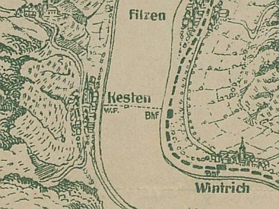 420 m
Ferries
Ehemalige Wagenfähre Kesten - Wintrich
No picture
530 m
Mills