Field Names · Historicism / Art Nouveau
Im rothen Sand überm Büschweg


© GeoBasis-DE / LVermGeoRP, dl-de/by-2-0
There is no picture of this object yet. Do you have a photo that you would like to make available to the Kulturdatenbank? Submit a picture
Description
This description is only available in German.
Translate with Google opens this page in Google Translate (external service)
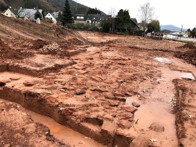
Benennung nach der Bodenart und nach dem Pfalzeler Büschweg, der noch zu Anfang unseres Jahrhunderts direkt zum Layweg und in den Pfalzeler Wald führte. [1]
Classification
- Subject area
- History
- Category
- Field Names
- Date
- 1856
Location
- District
- City of Trier
- Collective municipality
- Verbandsfreie Gemeinde Trier
- Town
- Trier
- Locality / location
- Pfalzel
- Field name
- [Bahngelände]
- Coordinates
- WGS 84: 49.788855, 6.681512 (Position: exact) WGS 84: 49° 47′ 19.9″ N, 6° 40′ 53.4″ E UTM 32 (ETRS89): E 333122 · N 5517734
Sources
Data sources
- [1] Werner Schuhn: Ehrang. Landschaft, Geschichte, Gegenwart. Trier, 1989. Hrsg. Arbeitsgemeinschaft für Landesgeschichte und Volkskunde des Trierer Raumes. Sonderausgabe der Trierer Heimat.
On the internet
Last edited: 13 Aug 2020 Object ID: 49894
https://kulturdb.de/en/objekt/49894-trier-im-rothen-sand-ueberm-bueschweg
Nearby
The nearest objects
Field Names
In den Sanken
Field Names
In der Leimkau
Field Names
In der Geisheck
Field Names
Am Büschweg
Field Names
Am Mäusheckerweg
 300 m
Road Transport
Reste einer Römerstraße
Field Names
Im rothen Sand auf'm Schmittchen
 330 m
Railways