Wayside Shrines and Stations of the Cross · 20th Century
Bildtafel (2)


Description
This description is only available in German.
Translate with Google opens this page in Google Translate (external service)
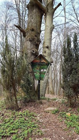
Beim Höhenpunkt 373,3 Meter über NHN. [1]
Classification
- Subject area
- Architectural and Art Monuments
- Category
- Religious Buildings
- Object type
- Wayside Shrines and Stations of the Cross
- Date
- 1993
- Period
- 20th Century
- Creator, builder, architect, artist
- Bergverein Detzem
Location
- District
- Trier-Saarburg
- Collective municipality
- Schweich an der römischen Weinstraße
- Municipality
- Detzem
- Field name
- In der Wolfskaul
- Coordinates
- WGS 84: 49.797041, 6.866412 (Position: exact) WGS 84: 49° 47′ 49.3″ N, 6° 51′ 59.1″ E UTM 32 (ETRS89): E 346455 · N 5518249
Sources
Data sources
- [1] Sandra Wack, Neuheilenbach, 2021. www.koerbchen-gesucht.de
On the internet
Picture credits
Last edited: 26 Apr 2021 Object ID: 50487
https://kulturdb.de/en/objekt/50487-detzem-bildtafel-2
Nearby
The nearest objects
 less than 10 m
Wayside Shrines and Stations of the Cross
Bildtafel (1)
No picture
70 m
Field Names
Im Grundbirngarten
 120 m
Wayside Shrines and Stations of the Cross
2 Wegekreuze
No picture
280 m
Field Names
In der Wolfskaul
 470 m
Road Transport
Spuren einer Römerstraße
 790 m
Extraction and Processing of Raw Materials
Ehemaliger Schieferstollen
No picture
800 m
Field Names
Hinterm Werth
No picture
810 m
Field Names