Water Supply · Undated
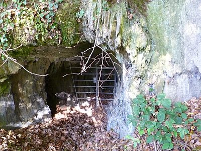
Römische Wasserleitung (Qanat) von Pölich


Description
This description is only available in German.
Translate with Google opens this page in Google Translate (external service)
Infotafel zur römischen Wasserleitung von Pölich:
Die römische Wasserleitung von Pölich versorgte 2 Villen und eine der prachtvollsten Badeanlagen des Trierer Landes mit Trink- und Badewasser [1]
Classification
- Subject area
- Archaeological Monuments
- Category
- Water Supply
- Date
- Undatiert
- Period
- Undated
Location
- District
- Trier-Saarburg
- Collective municipality
- Schweich an der römischen Weinstraße
- Municipality
- Pölich
- Field name
- Pölicherhelt
- Coordinates
- WGS 84: 49.795412, 6.855002 (Position: exact) WGS 84: 49° 47′ 43.5″ N, 6° 51′ 18.0″ E UTM 32 (ETRS89): E 345629 · N 5518091
Sources
Data sources
- [1] Infotafel vor Ort.
On the internet
Picture credits
Last edited: 29 Jul 2025 Object ID: 51901
https://kulturdb.de/en/objekt/51901-poelich-roemische-wasserleitung-qanat-von-poelich
Nearby
The nearest objects
 less than 10 m
Surveying
Leugenstein an der Römerstraße
 230 m
Extraction and Processing of Raw Materials
Ehemaliger Schieferstollen
Settlements
Römische Spolie
Town Houses and Commercial Buildings
Winzervilla
Rectories
Pfarrhaus
Farmhouses and Farm Buildings
Hofanwesen
Field Names
Hinterm Werth
Farmhouses and Farm Buildings