Rocks · Undated
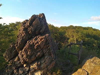
Bärbelley
Naturdenkmal
- Listed monument


Classification
- Subject area
- Natural Features
- Category
- Rocks
- Date
- Undatiert
- Period
- Undated
Location
- District
- Bernkastel-Wittlich
- Collective municipality
- Bernkastel-Kues
- Municipality
- Brauneberg
- Field name
- Aufm Wald
- Coordinates
- WGS 84: 49.848270, 7.028650 (Position: exact) WGS 84: 49° 50′ 53.8″ N, 7° 01′ 43.1″ E UTM 32 (ETRS89): E 358280 · N 5523625
Sources
Data sources
- [1] LANIS - Landschaftsinformationssysten der Naturschutzverwaltung Rheinland-Pfalz, 2015. http://www.naturschutz.rlp.de/?q=naturdenkmal
On the internet
Picture credits
Last edited: 2 May 2015 Object ID: 5290
https://kulturdb.de/en/objekt/5290-brauneberg-baerbelley
Nearby
The nearest objects
No picture
260 m
Field Names
Wüstwies
 360 m
Rocks
Barbelley Felsen
No picture
380 m
Mills
Mühle am Hesselbach
No picture
670 m
Mills
Klaramühle am Gornhauser Bach
No picture
670 m
Mills
Klaramühle
No picture
860 m
Burial Mounds
Grabhügel
No picture
960 m
Burial Mounds
Römische Grabhügel
No picture
1.0 km
Extraction and Processing of Raw Materials