Wayside Shrines and Stations of the Cross · Undated
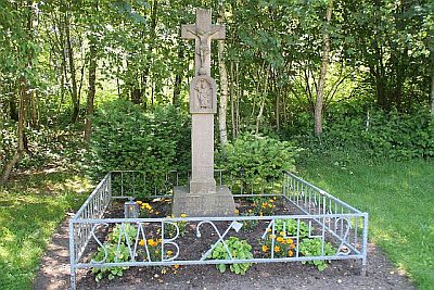
Sankt-Matthias-Bildstock


Description
This description is only available in German.
Translate with Google opens this page in Google Translate (external service)
Auf Höhenpunkt 487,2 Meter über Normal-Null.
Inschrift:
St. Matthias
Bruderschaft
Korschenbroich
1784 - 1984 [1]
Classification
- Subject area
- Architectural and Art Monuments
- Category
- Religious Buildings
- Object type
- Wayside Shrines and Stations of the Cross
- Date
- Undatiert
- Period
- Undated
Location
- District
- Eifelkreis Bitburg-Prüm
- Collective municipality
- Prüm
- Municipality
- Wallersheim
- Field name
- Beim Fotborn
- Coordinates
- WGS 84: 50.165193, 6.550252 (Position: exact) WGS 84: 50° 09′ 54.7″ N, 6° 33′ 00.9″ E UTM 32 (ETRS89): E 325046 · N 5559871
Sources
Data sources
- [1] Wanderkarte 1:25.000 Nr. 19 des Eifelvereins "Vulkaneifel um Gerolstein". Hrsg. VG Gerolstein in Zusammenarbeit mit dem Eifelverein e.V. 4. Auflage 1996.
On the internet
Picture credits
Last edited: 25 Feb 2012 Object ID: 5565
https://kulturdb.de/en/objekt/5565-wallersheim-sankt-matthias-bildstock
Nearby
The nearest objects
Field Names
Beim Fotborn
Field Names
Ober dem Fotborn
Field Names
Eichholz
 1.0 km
Wayside Shrines and Stations of the Cross
Sankt-Matthias-Bildstock von 1731
Field Names
Auf der Alwertsheld
Peat Cuttings
Ehemaliger Torfstich
Wayside Shrines and Stations of the Cross
Wegekreuz
Farmhouses and Farm Buildings