Place Names / Local History · Celtic / Roman Period
Ortsname
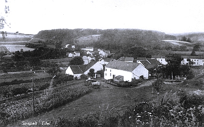
Description
This description is only available in German.
Translate with Google opens this page in Google Translate (external service)
1220: in villa Symonisvelt duo mansi mansi=Bleibe, Nachtquartier
Geschichte:
Zur Zeit der Römer war Sinspelt ein Straßenknotenpunkt. Es stand hier ein römisches Landhaus, die Simonis villa (Haus des Simons). Die erste urkundliche Erwähnung des Ortes stammt aus dem Jahre 1435.[1]
Classification
- Subject area
- History
- Category
- Place Names / Local History
- Date
- Circa 500 vor Chr. bis circa 500 nach Chr.
- Period
- Celtic / Roman Period
Location
- District
- Eifelkreis Bitburg-Prüm
- Collective municipality
- Südeifel
- Municipality
- Sinspelt
- Field name
- Ortslage
- Coordinates
- WGS 84: 49.972381, 6.320254 (Position: within the village) WGS 84: 49° 58′ 20.6″ N, 6° 19′ 12.9″ E UTM 32 (ETRS89): E 307852 · N 5539002
Sources
Data sources
- [1] Dipl. Ing. Rolf Robischon / Internet
On the internet
de.wikipedia.org/wiki/Sinspelt
Picture credits
- Picture 1: Ansichtskarte von 1939. Sammlung Michael Haenel, 2024. http://www.quellenatlas.eu/
Last edited: 11 Aug 2024 Object ID: 7209
https://kulturdb.de/en/objekt/7209-sinspelt-ortsname
Nearby
The nearest objects
Farmhouses and Farm Buildings
Hofanlage Coumont
Catholic Churches
Maria Königin
War Memorials
Friedhofskreuz
Extraction and Processing of Raw Materials
Ehemaliger Steinbruch
Mills
Ehemalige Mühle
Field Names
Auf dem Batzendells Flürchen
Mills
Sinspelter Mühle an der Enz
Field Names