Wayside Shrines and Stations of the Cross · Renaissance
Schaftkreuz von 1661
- Listed monument


© GeoBasis-DE / LVermGeoRP, dl-de/by-2-0
There is no picture of this object yet. Do you have a photo that you would like to make available to the Kulturdatenbank? Submit a picture
Description
This description is only available in German.
Translate with Google opens this page in Google Translate (external service)
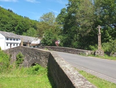
Im Osten am Weg oberhalb des bewaldeten, steil zur Nims abfallenden Hang, steht der obere Teil eines Schaftkreuzes in einem mächtigem Sockelstein, der grade noch einen Mühlenhammer erkennen läßt. Es ist mit einer möglicherweise 1661 zu lesenden Jahreszahl versehen.
Classification
- Subject area
- Architectural and Art Monuments
- Category
- Religious Buildings
- Object type
- Wayside Shrines and Stations of the Cross
- Date
- 1661
- Period
- Renaissance
Location
- District
- Eifelkreis Bitburg-Prüm
- Collective municipality
- Bitburger Land
- Municipality
- Schleid
- Field name
- Beim Kreuz
- Coordinates
- WGS 84: 50.062552, 6.497913 (Position: exact) WGS 84: 50° 03′ 45.2″ N, 6° 29′ 52.5″ E UTM 32 (ETRS89): E 320925 · N 5548584
Sources
Data sources
- Homepage der Initiative Region Trier e.V. Sehen & Erleben - Bau-Denkmäler http://www.regiontrier.de/cgi/bin
On the internet
Last edited: 7 Mar 2005 Object ID: 9515
https://kulturdb.de/en/objekt/9515-schleid-schaftkreuz-von-1661
Nearby
The nearest objects
Wayside Shrines and Stations of the Cross
Wegekreuz
Field Names
Unterm Scheid
Farmhouses and Farm Buildings
Ehemaliges Flurküchenhaus
 290 m
Wayside Shrines and Stations of the Cross
Brücke über die Nims - Wegekreuz
Field Names
Aufm Scheid
290 m
Road Transport
Brücke über die Nims
Farmhouses and Farm Buildings
Wohnhaus
Field Names