Coats of Arms · 20th Century
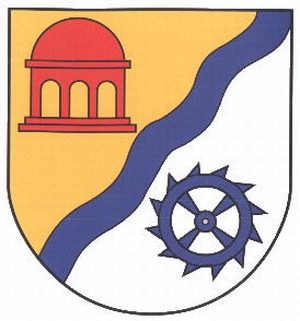
Wappen der Gemeinde Mülbach

Description
This description is only available in German.
Translate with Google opens this page in Google Translate (external service)
Der blaue Wellenbalken, symbolisierend den Mühlenbach, teilt das Wappen in einen roten Tempel auf gelbem Grund, der für die Anwesenheit der Tempelritter steht und die Farben der Grafschaft Manderscheid trägt sowie in ein blaues Mühlrad auf silbernem Grund, symbolisierend die Mühlen mit den luxemburgischen Landesfarben.
Classification
- Subject area
- History
- Category
- Coats of Arms
- Date
- 05.11.1985 [Genehmigung]
- Period
- 20th Century
Location
- District
- Eifelkreis Bitburg-Prüm
- Collective municipality
- Bitburger Land
- Municipality
- Mülbach
- Field name
- Ortslage
- Coordinates
- WGS 84: 49.967623, 6.404132 (Position: within the village) WGS 84: 49° 58′ 03.4″ N, 6° 24′ 14.9″ E UTM 32 (ETRS89): E 313848 · N 5538261
Sources
Data sources
- Homepage der Verbandsgemeinde Bitburg-Land
On the internet
bitburgerland.de/index.php?id=416
Picture credits
- Picture 1: http://www.ngw.nl/int/dld/m/mulbach.htm
Last edited: 5 Sep 2005 Object ID: 10220
https://kulturdb.de/en/objekt/10220-muelbach-wappen-der-gemeinde-muelbach
Nearby
The nearest objects
 less than 10 m
Place Names / Local History
Ortsgeschichte Mülbach
 140 m
Mills
Alte Mühle
 160 m
Chapels
Kapelle beim Hof Bachstraße
 330 m
Wayside Shrines and Stations of the Cross
Dankeskreuz
Mills
Oberste Mühle
Field Names
Im Krummfeld
Field Names
In den Grundwiesen
Wayside Shrines and Stations of the Cross