Place Names / Local History · Renaissance
Ortsgeschichte Bereborn (2)


© GeoBasis-DE / LVermGeoRP, dl-de/by-2-0
There is no picture of this object yet. Do you have a photo that you would like to make available to the Kulturdatenbank? Submit a picture
Description
This description is only available in German.
Translate with Google opens this page in Google Translate (external service)
Der Ort gehörte in der Feudalzeit zur Grafschaft Virneburg, das unter der französichen Besatzung zum Kantonsitz wurde. Unter preußischer Verwaltung war Bereborn Gemeinde in der Bürgermeisterei Virneburg. Bei der Bildung der Verbandsgemeinde Kelberg im Zuge der Verwaltungsreform 1970 wurde das Dorf mit anderen Orten der Verbandsgemeinde aus dem Landkreis Mayen, Regierungsbezirk Koblenz, ausgelöst und dem Landkreis Daun zugeordnet.
Classification
- Subject area
- History
- Category
- Place Names / Local History
- Date
- 1542
- Period
- Renaissance
Location
- District
- Vulkaneifel
- Collective municipality
- Kelberg
- Municipality
- Bereborn
- Field name
- Ortslage
- Coordinates
- WGS 84: 50.280840, 6.971303 (Position: within the village) WGS 84: 50° 16′ 51.0″ N, 6° 58′ 16.7″ E UTM 32 (ETRS89): E 355463 · N 5571825
Sources
Data sources
On the internet
Last edited: 1 Dec 2005 Object ID: 10558
https://kulturdb.de/en/objekt/10558-bereborn-ortsgeschichte-bereborn-2
Nearby
The nearest objects
Place Names / Local History
Erste Erwähnung als Berreboir
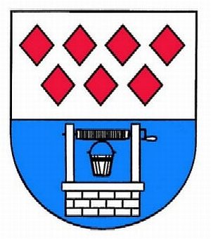 less than 10 m
Coats of Arms
Wappen der Gemeinde Bereborn
 40 m
Commemorative Plantings
Kaiserlinde mit Gedenkstein
Field Names
Im Grund
Catholic Churches
Sankt Quirinus
Wayside Shrines and Stations of the Cross
Wegekreuz
Wayside Shrines and Stations of the Cross
Wegekreuz
Field Names