Settlements · Gothic
Historische Siedlung Barbeln


Description
This description is only available in German.
Translate with Google opens this page in Google Translate (external service)
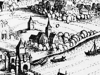
Unten am Moselufer, hinter der Römerbrücke in Richtung Konz, lag die bis 1888 selbständige Gemeinde Sankt Barbara, deren Urzelle das gleichnamige Kloster aus dem 12. Jahrhundert war.
In dem Viertel Sankt Barbara-Ufer, untere Kapellenstraße, Nikolaus- und Gilbertstraße, jetzige Speestraße und der untere Teil der Südallee, wohnten im 19. Jahrhundert etwa 1000 bis 1500 Menschen. [1]
Classification
- Subject area
- Archaeological Monuments
- Category
- Settlements
- Object type
- Settlements
- Date
- 13./14. Jahrhundert
- Period
- Gothic
Location
- District
- City of Trier
- Collective municipality
- Verbandsfreie Gemeinde Trier
- Town
- Trier
- Locality / location
- Trier-Süd
- Street
- Sankt-Barbara-Ufer / Nikolausstraße
- Field name
- Ortslage
- Coordinates
- WGS 84: 49.748606, 6.628563 (Position: exact) WGS 84: 49° 44′ 55.0″ N, 6° 37′ 42.8″ E UTM 32 (ETRS89): E 329169 · N 5513379
Sources
Data sources
- [1] Rettet das archäologische Erbe in Trier. Schriftenreihe des Rheinischen Landesmuseums Trier. Nr. 31. ISBN 3-923319-62-2 Online-Shop: www.landesmuseum-trier-shop.de
- [2] Annegret van Stipelen-Kintzinger: Trier in alten Ansichten. Europäische Bibliothek - Zaltbommel / Niederlande 1980; ISBN 90 288 1033 1.
On the internet
de.wikipedia.org/wiki/Trier-S%C3%BCd
Picture credits
Last edited: 3 Nov 2021 Object ID: 11118
https://kulturdb.de/en/objekt/11118-trier-sued-historische-siedlung-barbeln
Nearby
The nearest objects
 10 m
Monastic Complexes
Ehemaliges Kloster Sankt Barbara
Town Houses and Commercial Buildings
Ehemalige Wohnhäuser Barbara-Ufer
Town Houses and Commercial Buildings
Wohnhaus
Town Houses and Commercial Buildings
Wohnhaus
Town Houses and Commercial Buildings
Wohnhaus
Town Houses and Commercial Buildings
Wohnhaus
 60 m
Town Houses and Commercial Buildings
Wohnhaus
Town Fortifications