Town Houses and Commercial Buildings · Early Middle Ages / Romanesque
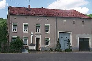
Gewölbekeller
- Listed monument

Description
This description is only available in German.
Translate with Google opens this page in Google Translate (external service)
Auf dem Grundstück des ehemaligen Klosterhofes vermutlich aus romanischer Zeit. Zeugnis der ehemaligen Benediktinerpropstei Langsur, gehörte im Mittelalter zu den Trierer Abteien Sankt Eucharius und Sankt Matthias, Nutzung als Bürgersaal.
Classification
- Subject area
- Architectural and Art Monuments
- Category
- Residential and Farm Buildings
- Object type
- Town Houses and Commercial Buildings
- Date
- Circa 500 nach Chr. bis circa 1220
Location
- District
- Trier-Saarburg
- Collective municipality
- Trier-Land
- Municipality
- Langsur
- Street
- Mesenicher Straße 64
- Field name
- Ortslage
- Coordinates
- WGS 84: 49.724421, 6.503431 (Position: exact) WGS 84: 49° 43′ 27.9″ N, 6° 30′ 12.4″ E UTM 32 (ETRS89): E 320067 · N 5510983
Sources
Data sources
- Digitales Denkmalbuch
On the internet
Picture credits
- Picture 1: © Helge Rieder, Konz, 2000
Last edited: 22 Jun 2006 Object ID: 1224
https://kulturdb.de/en/objekt/1224-langsur-gewoelbekeller
Nearby
The nearest objects
Fords
Ehemalige Furt durch die Sauer
Fords
Ehemalige Furt durch die Sauer
War Memorials
Kriegerdenkmal am Friedhof
 290 m
Wayside Shrines and Stations of the Cross
Kreuzigungsbildstock
Settlements
Mauern eines römischen Gebäudes
Chapels
Kapelle am Friedhof
Vineyard Sites
Brüderberg
Wayside Shrines and Stations of the Cross