Farmhouses and Farm Buildings · Historicism / Art Nouveau
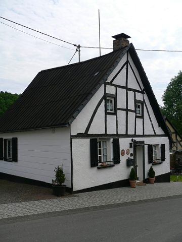
Gemeindebackhaus
- Listed monument

Description
This description is only available in German.
Translate with Google opens this page in Google Translate (external service)
Classification
- Subject area
- Architectural and Art Monuments
- Category
- Residential and Farm Buildings
- Object type
- Farmhouses and Farm Buildings
- Date
- 1880
Location
- District
- Vulkaneifel
- Collective municipality
- Daun
- Municipality
- Demerath
- Locality / location
- Unterdorf
- Street
- Gartenweg 1
- Field name
- Ortslage
- Coordinates
- WGS 84: 50.173785, 6.949350 (Position: exact) WGS 84: 50° 10′ 25.6″ N, 6° 56′ 57.7″ E UTM 32 (ETRS89): E 353572 · N 5559966
Sources
Data sources
- [1] Denkmalliste des Landes Rheinland-Pfalz (Stand: 3. Januar 2013).
- [2] Internetseite der Ortsgemeinde Demerath / Vulkaneifel. Http://www.demerath-eifel.de/?Rpage=kultur/?Rpage=
On the internet
Picture credits
- Picture 1: http://www.daun.de/vgv/tourist/galerie/index.html
Last edited: 13 Oct 2008 Object ID: 1481
https://kulturdb.de/en/objekt/1481-demerath-gemeindebackhaus
Nearby
The nearest objects
 20 m
Farmhouses and Farm Buildings
Fachwerkhaus
No picture
50 m
Farmhouses and Farm Buildings
Wohnhaus
No picture
60 m
Farmhouses and Farm Buildings
Quereinhaus
No picture
100 m
Field Names
Paukelspesch
No picture
120 m
Farmhouses and Farm Buildings
Streckhof
No picture
170 m
Chapels
Kapelle Heiliger Judas Thaddäus
No picture
180 m
Wayside Shrines and Stations of the Cross
Bildstock an der Leichenhalle
No picture
190 m
Oaks