Wayside Shrines and Stations of the Cross · Baroque / Rococo
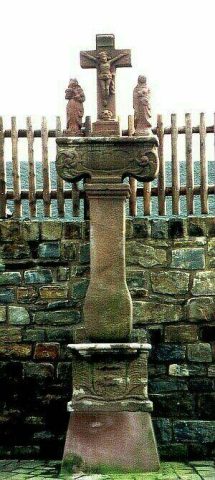
Kreuz am Bernardyshof


Description
This description is only available in German.
Translate with Google opens this page in Google Translate (external service)
Cirka 200 Meter nordwestlich vom Bernardyshof am Steine-Berg.
Inschrift auf der Rückseite:
1736
H H
Classification
- Subject area
- Architectural and Art Monuments
- Category
- Religious Buildings
- Object type
- Wayside Shrines and Stations of the Cross
- Date
- 1736
- Period
- Baroque / Rococo
Location
- District
- Vulkaneifel
- Collective municipality
- Gerolstein
- Municipality
- Kerpen (Eifel)
- Locality / location
- Bernardyshof
- Field name
- Oben im Breitenweg
- Coordinates
- WGS 84: 50.320744, 6.732635 (Position: exact) WGS 84: 50° 19′ 14.7″ N, 6° 43′ 57.5″ E UTM 32 (ETRS89): E 338596 · N 5576752
Sources
Data sources
- [1] Clemens Baasch, 54570 Wallenborn
On the internet
Picture credits
Last edited: 6 Dec 2009 Object ID: 17731
https://kulturdb.de/en/objekt/17731-kerpen-eifel-kreuz-am-bernardyshof
Nearby
The nearest objects
Wayside Shrines and Stations of the Cross
Wegekreuz
 450 m
Wayside Shrines and Stations of the Cross
Wegekreuz
 500 m
Ash Trees
Esche
Field Names
Auf dem obersten Mühlenstück
 590 m
Field Names
Im Tiergarten
Chapels
Kapelle
Field Names
Im Bungert
Field Names