Wayside Shrines and Stations of the Cross · Baroque / Rococo
Hubertuskreuz

Description
This description is only available in German.
Translate with Google opens this page in Google Translate (external service)
Im Wald nordöstlich des Schwickerather Hofes: kleines Barockes Schaftkreuz von 1773 mit stark gebauchtem Schaft, der Errichtername wegen teilweise spiegelbildlicher oder auf dem Kopf stehender Buchstaben nicht ganz eindeuig zu lesen, wohl WILHELM BLOHM. Das verhältnismäßig große Abschlusskreuz als Kleeblattkreuz ausgebildet. [1]
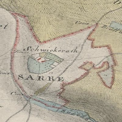
In der Tranchot-Karte von 1811 markiert das Kreuz die Grenze des Hofes. [2]
Classification
- Subject area
- Architectural and Art Monuments
- Category
- Religious Buildings
- Object type
- Wayside Shrines and Stations of the Cross
- Date
- 1773
- Period
- Baroque / Rococo
Location
- District
- Eifelkreis Bitburg-Prüm
- Collective municipality
- Bitburger Land
- Municipality
- Seinsfeld
- Locality / location
- Schwickerather Hof
- Field name
- Unterste Dorfgüth
- Coordinates
- WGS 84: 50.077611, 6.658119 (Position: exact) WGS 84: 50° 04′ 39.4″ N, 6° 39′ 29.2″ E UTM 32 (ETRS89): E 332443 · N 5549887
Sources
Data sources
- [1] Denkmaltopographie Bundesrepublik Deutschland, Kulturdenkmäler in Rheinland-Pfalz, Kreis Bitburg-Prüm, 9.1 Wernersche Verlagsgesellschaft 1994. ISBN 3-88462-081-9
- [2] Kartenaufnahme der Rheinlande durch Tranchot und von Müffling (1803-1820) Blattnummer: 178, Jahrgang: 1811, Blattname: Kyllburg, Aufnahme: Ing. Geograph Boucher © GeoBasis-DE / LVermGeoRP 2016, dl-de/by-2-0, www.lvermgeo.rlp.de
On the internet
bitburgerland.de/index.php?id=1628
Picture credits
- Picture 1: Kartenaufnahme der Rheinlande durch Tranchot und von Müffling (1803-1820) Blattnummer: 178, Jahrgang: 1811, Blattname: Kyllburg, Aufnahme: Ing. Geograph Boucher © GeoBasis-DE / LVermGeoRP 2016, dl-de/by-2-0, www.lvermgeo.rlp.de
Last edited: 29 Jan 2023 Object ID: 25611
https://kulturdb.de/en/objekt/25611-seinsfeld-hubertuskreuz
Nearby
The nearest objects
 710 m
Place Names / Local History
Schwickerather Hof
Field Names
In der Wolfskaul
Forest Names
Königlicher Forst Gerolstein
Lime Kilns
Ehemaliger Kalkofen
Wayside Shrines and Stations of the Cross
Ehemaliges Wegekreuz
Deserted Settlements
Ehemaliger Hof Raeckert
Wayside Shrines and Stations of the Cross
Ehemaliges Wegekreuz
Field Names