Wayside Shrines and Stations of the Cross · Baroque / Rococo
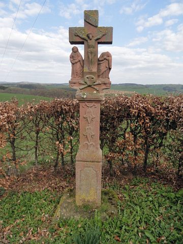
Nischenkreuz
- Listed monument


© GeoBasis-DE / LVermGeoRP, dl-de/by-2-0
There is no picture of this object yet. Do you have a photo that you would like to make available to the Kulturdatenbank? Submit a picture
Description
This description is only available in German.
Translate with Google opens this page in Google Translate (external service)
Südlich des Ortes, an einer Feldwegekreuzung: Wegekreuz; nachgotisches Nischenkreuz, bezeichnet 1717. [1]
Classification
- Subject area
- Architectural and Art Monuments
- Category
- Religious Buildings
- Object type
- Wayside Shrines and Stations of the Cross
- Date
- 1717
- Period
- Baroque / Rococo
Location
- District
- Eifelkreis Bitburg-Prüm
- Collective municipality
- Prüm
- Municipality
- Winringen
- Field name
- In Örig
- Coordinates
- WGS 84: 50.150511, 6.415652 (Position: exact) WGS 84: 50° 09′ 01.8″ N, 6° 24′ 56.3″ E UTM 32 (ETRS89): E 315377 · N 5558563
Sources
Data sources
- [1] Denkmalliste der Generaldirektion Kulturelles Erbe, Rheinland-Pfalz; 2010.
On the internet
Last edited: 13 Jun 2015 Object ID: 26038
https://kulturdb.de/en/objekt/26038-winringen-nischenkreuz
Nearby
The nearest objects
Temples, Sanctuaries
Gallo-römisches Heiligtum
Field Names
Auf der Küsterei
Place Names / Local History
Ortsname / Ortsgeschichte
Wayside Shrines and Stations of the Cross
Wegekreuz
Wayside Shrines and Stations of the Cross
Wegekreuz
Field Names
Im Eiswinkel
Extraction and Processing of Raw Materials
Ehemaliger Steinbruch am Handich
 960 m
Wayside Shrines and Stations of the Cross