Extraction and Processing of Raw Materials · Neoclassicism
Ehemaliger Schacht einer Bleierzgrube

Description
This description is only available in German.
Translate with Google opens this page in Google Translate (external service)
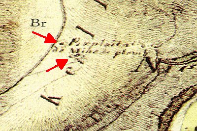
1810 / 11 enthält die Tranchot-Karte 152 Bleialf den Vermerk Exploitations de Mine de plomb mit zwei Schächten. [1]
Classification
- Subject area
- Architectural and Art Monuments
- Category
- Economy, Trade and Transport
- Object type
- Extraction and Processing of Raw Materials
- Date
- 1810
- Period
- Neoclassicism
Location
- District
- Eifelkreis Bitburg-Prüm
- Collective municipality
- Prüm
- Municipality
- Buchet
- Field name
- Bertaschacht
- Coordinates
- WGS 84: 50.248390, 6.304770 (Position: exact) WGS 84: 50° 14′ 54.2″ N, 6° 18′ 17.2″ E UTM 32 (ETRS89): E 307851 · N 5569724
Sources
Data sources
- [1] Janssen, W.: Studien zur Wüstungsfrage im fränkischen Altsiedelland zwischen Rhein, Mosel und Eifelnordrand. 2 Bände. Text u. Katalog, 1975.
On the internet
Picture credits
- Picture 1: Kartenaufnahme der Rheinlande durch Tranchot und von Müffling (1803-1820) © GeoBasis-DE / LVermGeoRP 2016, dl-de/by-2-0, www.lvermgeo.rlp.de [Daten bearbeitet]© GeoBasis-DE / LVermGeoRP 2016, dl-de/by-2-0, www.lvermgeo.rlp.de [Daten bearbeitet]
Last edited: 8 Jan 2017 Object ID: 42621
https://kulturdb.de/en/objekt/42621-buchet-ehemaliger-schacht-einer-bleierzgrube
Nearby
The nearest objects
 110 m
Extraction and Processing of Raw Materials
Ehemaliger Schacht einer Bleierzgrube
Extraction and Processing of Raw Materials
Ehemaliger Schacht einer Bleierzgrube
Field Names
Auf Fischendell
Extraction and Processing of Raw Materials
Ehemalige Bleigrube Bertaschacht (Alt)
540 m
Extraction and Processing of Raw Materials
Ehemalige Bleigrube Bertaschacht (Neu)
Wayside Shrines and Stations of the Cross
Wegekreuz
Field Names
Omborn
Field Names