Viewpoints · Undated
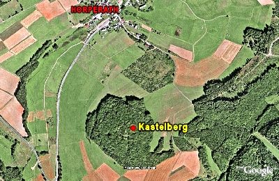
Kastelberg


Classification
- Subject area
- Natural Features
- Category
- Viewpoints
- Date
- Undatiert
- Period
- Undated
Location
- District
- Vulkaneifel
- Collective municipality
- Kelberg
- Municipality
- Horperath
- Field name
- Auf Kastel
- Coordinates
- WGS 84: 50.239453, 6.954467 (Position: exact) WGS 84: 50° 14′ 22.0″ N, 6° 57′ 16.1″ E UTM 32 (ETRS89): E 354138 · N 5567257
Sources
Data sources
- [1] Wanderkarten im Maßstab 1:50.000 und 1:25.000.
On the internet
Picture credits
Last edited: 27 Dec 2007 Object ID: 4842
https://kulturdb.de/en/objekt/4842-horperath-kastelberg
Nearby
The nearest objects
 less than 10 m
Hilltop Castles
Kastelberg
less than 10 m
Hilltop Castles
Kastelberg (2)
less than 10 m
Temples, Sanctuaries
Bergheiligtum auf dem Kaselberg
No picture
300 m
Field Names
Im Kastels Sur
No picture
310 m
Field Names
Im Kastels Sur
 530 m
Commemorative Plantings
Kaiserlinde mit Gedenkstein
No picture
560 m
Place Names / Local History
Ortsgeschichte Horperath
 560 m
Coats of Arms