Rocks · 20th Century
Basaltblöcke und Felsen in der "Dauner Heck"
Naturdenkmal
- Listed monument

Description
This description is only available in German.
Translate with Google opens this page in Google Translate (external service)
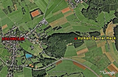
Basaltblöcke und Felsen auf einer Fläche von rund 70 x 100 m, die sich bis zu einer Höhe von 20 m erheben. [1]
Classification
- Subject area
- Natural Features
- Category
- Rocks
- Date
- 16.08.1938 [Unterschutzstellung]
- Period
- 20th Century
Location
- District
- Vulkaneifel
- Collective municipality
- Daun
- Municipality
- Kirchweiler
- Field name
- Die Dauner Heck
- Coordinates
- WGS 84: 50.230550, 6.753680 (Position: exact) WGS 84: 50° 13′ 50.0″ N, 6° 45′ 13.2″ E UTM 32 (ETRS89): E 339791 · N 5566679
Sources
Data sources
- [1] Rita Gehendges: Naturdenkmale des Landkreises Daun. 1985. Hrsg.: Landkreis Daun.
- [2] LANIS - Landschaftsinformationssysten der Naturschutzverwaltung Rheinland-Pfalz, 2015. http://www.naturschutz.rlp.de/?q=naturdenkmal
On the internet
Picture credits
- Picture 1: Peter Valerius, Kordel, 2005.
Last edited: 13 May 2015 Object ID: 5144
https://kulturdb.de/en/objekt/5144-kirchweiler-basaltbloecke-und-felsen-in-der-dauner-heck
Nearby
The nearest objects
Extraction and Processing of Raw Materials
Mühlsteinbruch Dauner Heck
 210 m
Volcanoes
Vulkan Dauner Heck
Field Names
Ober dem Messenpfad
Field Names
Im Klingelborn
Wayside Shrines and Stations of the Cross
Wegekreuz
Dry Maars
Unterirdisches Maar
Field Names
Unter dem Messenpfad
Field Names