Rocks · 20th Century
Kopp - Basaltgipfel
Naturdenkmal
- Listed monument

Description
This description is only available in German.
Translate with Google opens this page in Google Translate (external service)
Tertiärer Basaltgipfel - Höhe 525,2 m über Normal-Null..
Classification
- Subject area
- Natural Features
- Category
- Rocks
- Date
- 25.09.1939 [Unterschutzstellung]
- Period
- 20th Century
Location
- District
- Vulkaneifel
- Town
- Daun
- Locality / location
- Waldkönigen
- Field name
- Kolwerath am Köpfchen Hunert
- Coordinates
- WGS 84: 50.219531, 6.816485 (Position: exact) WGS 84: 50° 13′ 10.3″ N, 6° 48′ 59.3″ E UTM 32 (ETRS89): E 344234 · N 5565321
Sources
Data sources
- Rita Gehendges: Naturdenkmale des Landkreises Daun. 1985. Hrsg.: Landkreis Daun.
On the internet
Picture credits
- Picture 1: Peter Valerius, Kordel, 2005.
Last edited: 21 Feb 2012 Object ID: 5147
https://kulturdb.de/en/objekt/5147-daun-kopp-basaltgipfel
Nearby
The nearest objects
 20 m
Volcanoes
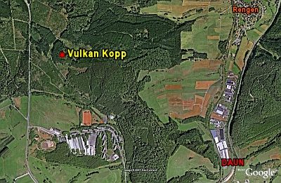
Vulkan Kopp
No picture
410 m
Wayside Shrines and Stations of the Cross
Wegekreuz
No picture
570 m
Field Names
Erlen Kolwerather Wasen
No picture
810 m
Field Names
Auf Kolwerath
No picture
930 m
Field Names
Auf Kolwerath
No picture
940 m
Field Names
Im Wolfsgraben
 1.0 km
Settlements
Römische Siedlungsstelle
No picture
1.1 km
Field Names