Wayside Shrines and Stations of the Cross · Renaissance
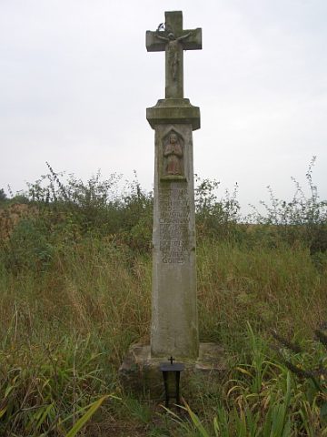
Klausenkreuz
- Listed monument


Description
This description is only available in German.
Translate with Google opens this page in Google Translate (external service)
Südlich der Ortslage am Thomasberg: Wegekreuz; Schaftkreuz, bezeichnet 1699. [1]
Classification
- Subject area
- Architectural and Art Monuments
- Category
- Religious Buildings
- Object type
- Wayside Shrines and Stations of the Cross
- Date
- 1699
- Period
- Renaissance
Location
- District
- Bernkastel-Wittlich
- Collective municipality
- Wittlich-Land
- Municipality
- Klausen
- Locality / location
- Krames-Klausen
- Field name
- Beim Schenkenborn
- Coordinates
- WGS 84: 49.893704, 6.889066 (Position: exact) WGS 84: 49° 53′ 37.3″ N, 6° 53′ 20.6″ E UTM 32 (ETRS89): E 348388 · N 5528949
Sources
Data sources
- [1] Denkmalliste der Generaldirektion Kulturelles Erbe, Rheinland-Pfalz; 2010.
On the internet
Picture credits
Last edited: 11 Feb 2012 Object ID: 5560
https://kulturdb.de/en/objekt/5560-klausen-klausenkreuz
Nearby
The nearest objects
 240 m
Viewpoints
Aussichtspunkt Klausenkreuz
 270 m
Field Names
Auf der Schlehenheck
No picture
280 m
Field Names
Beim Schenkenborn
No picture
390 m
Find Sites
Römische Ziegel- und Keramikfragmente
No picture
570 m
Viewpoints
Aussichtspunkt Krames
No picture
690 m
Field Names
Beim Meisborn
No picture
740 m
Field Names
Beim Drieschseufen
No picture
830 m
Viewpoints