Hinterweiler
65 heritage sites in Hinterweiler in the Kulturdatenbank Region Trier.
The map shows all 65 results.
-
Trigonometrisches Signal
Markers and Monuments Surveying ID 49608
-
Unten in der Bornwies
Field Names ID 32193
-
Unter Erzenrech
Field Names ID 36162
-
Unter Erzenrech
Field Names ID 36163
-
Unter Winkel auf den Sühren
Field Names ID 39915
-
Unter dem Ahnborn
Field Names ID 32194
-
Unter dem Messenpfad
Field Names ID 38393
-
Unter dem Mühlenrech
Field Names ID 29945
-
Unter dem Tönnespesch
Field Names ID 27193
-
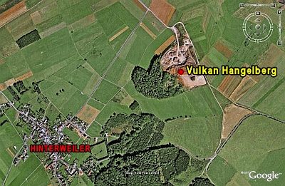
Vulkan Hangelberg
Geological Features Volcanoes ID 6634
-
Wegekreuz
Religious Buildings Wayside Shrines and Stations of the Cross ID 26342
-
Wegekreuz
Religious Buildings Wayside Shrines and Stations of the Cross ID 26343
-
Wegekreuz
Religious Buildings Wayside Shrines and Stations of the Cross ID 26344
-
Wegekreuz
Religious Buildings Wayside Shrines and Stations of the Cross ID 26345
-
Wegekreuz
Religious Buildings Wayside Shrines and Stations of the Cross ID 33607
-
Wüstung Oberweiler
Settlements Deserted Settlements ID 785